


Prairie Point 2 Voting District, Platte County, Missouri
About
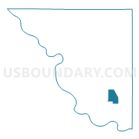
Outline

Summary
| Unique Area Identifier | 609429 |
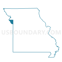
| Name | Prairie Point 2 Voting District |
| County | Platte County |
| State | Missouri |
| Area (square miles) | 4.65 |
| Land Area (square miles) | 4.65 |
| Water Area (square miles) | 0.00 |
| % of Land Area | 100.00 |
| % of Water Area | 0.00 |
| Latitude of the Internal Point | 39.26038990 |
| Longtitude of the Internal Point | -94.67863480 |
Maps

Graphs
Select a template below for downloading or customizing gragh for Prairie Point 2 Voting District, Platte County, Missouri


Neighbors
Neighoring Voting District (by Name) Neighboring Voting District on the Map
- Barry North 40 Voting District, Platte County, MO
- Embassy 11 Voting District, Platte County, MO
- Hampton East 15 Voting District, Platte County, MO
- Linkville 33 Voting District, Platte County, MO
- Park Hill North 41 Voting District, Platte County, MO
- Tiffany Springs 32 Voting District, Platte County, MO
- Weatherby Lake 10 Voting District, Platte County, MO
Top 10 Neighboring County Subdivision (by Population) Neighboring County Subdivision on the Map
- May township, Platte County, MO (23,500)
- Carroll township, Platte County, MO (14,970)
- Fox township, Platte County, MO (11,791)
- Kickapoo township, Platte County, MO (5,140)
Top 10 Neighboring Place (by Population) Neighboring Place on the Map
Top 10 Neighboring Unified School District (by Population) Neighboring Unified School District on the Map
Top 10 Neighboring State Legislative District Lower Chamber (by Population) Neighboring State Legislative District Lower Chamber on the Map
Top 10 Neighboring State Legislative District Upper Chamber (by Population) Neighboring State Legislative District Upper Chamber on the Map
Top 10 Neighboring 111th Congressional District (by Population) Neighboring 111th Congressional District on the Map
Top 10 Neighboring Census Tract (by Population) Neighboring Census Tract on the Map
- Census Tract 302.09, Platte County, MO (7,799)
- Census Tract 302.07, Platte County, MO (5,283)
- Census Tract 303.08, Platte County, MO (5,023)
- Census Tract 302.11, Platte County, MO (2,899)
- Census Tract 302.08, Platte County, MO (2,470)
- Census Tract 302.01, Platte County, MO (1,817)
- Census Tract 302.10, Platte County, MO (1,720)
- Census Tract 303.07, Platte County, MO (11)